The Chair of Climate Resilience of Cultural Ecosystems at the Center for Climate Resilience Receives Google Grant to Advance Air Pollution Modelling with Satellite Embeddings
Google’s Satellite Embeddings Dataset is a newly released global resource that introduces a different way of working with satellite information. Instead of relying on raw satellite images — which normally require multiple steps of technical preprocessing — Google uses a large AI model to convert each scene into a compact numerical representation called an embedding. These embeddings summarize what is visible on the ground in a standardized, ready-to-use format. They reflect landscape characteristics such as the density of buildings, vegetation cover, and the structure of roads and urban blocks. These are features that typically require advanced image analysis, yet the embedding dataset makes them available instantly and consistently across the globe. Among more than 200 proposals submitted worldwide, the project was recognized for its innovative use of Google’s new AI-based satellite embeddings to estimate air pollution patterns in a complex Andean urban landscape. The grant supports new research approaches where traditional air-quality monitoring infrastructure is limited. In this research, the embeddings are used as the only input to machine-learning models that estimate concentrations of NO? and PM?.? in Quito. The idea is to examine how much information is already contained in the embeddings themselves. If they successfully capture patterns associated with air pollution — without adding extra data such as meteorology, land use, or traffic — this could open the door to new low-cost approaches for environmental monitoring. Quito provides a meaningful setting to test this concept. Located in a narrow valley of the Andes and experiencing rapid urbanization, the city faces well-known challenges with air quality. At the same time, the number of monitoring stations is limited. If satellite embeddings can help identify spatial pollution patterns in such a setting, they may offer valuable insights for other cities in the Global South where environmental data remains scarce. The first results of this work have already been published in Remote Sensing (MDPI), where we evaluated the ability of Google Earth Satellite Embeddings to predict NO? and PM?.? levels in Quito. The article can be accessed here: https://www.mdpi.com/2072-4292/17/20/3472. These initial findings show promising potential and lay the groundwork for further development. The next stage of the research is to test the approach on a larger and more diverse dataset, particularly using open air-quality information from the European Environment Agency (EEA), for which the prize money will be used. Applying the method to a broader range of European cities will help evaluate its generalizability across different climates, urban structures, and environmental conditions. Google formally acknowledged the project’s scientific potential in the official confirmation letter dated October 29, 2025. ? Citation: Alvarez, C. I., Ulloa Vaca, C. A., & Echeverria Llumipanta, N. A. (2025). Machine Learning for Urban Air Quality Prediction Using Google AlphaEarth Foundations Satellite Embeddings: A Case Study of Quito, Ecuador.?Remote Sensing,?17(20), 3472. https://doi.org/10.3390/rs17203472 ? ? ? ? ?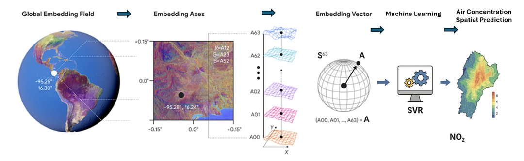
Wissenschaftlicher Kontakt